8:00 am - 5:00 pm
Sun - Thurs
Diyala
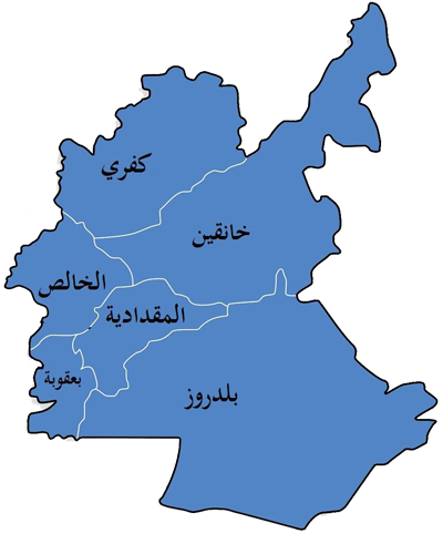
The area of Jalawla district is 467 km2, and it is located at the southwestern end of Khanaqin District, 32 km from the center of this district. It is bordered to the east by the Sirwan River (Diyala), and is about 160 km away from the capital, Baghdad. Most of its residents are Muslims, and it includes mainly Kurdish and Arab nationalism, as well as Turkmen. Jalawla district represents one of the four districts that make up the district of Khanaqin, located on the western side of it, on the north is Kulah Jaw district, on the west (Qara Tappah district), and on the south is Qarbat (Al-Saadia) district and a series of highlands. As for the internal borders of the district, the borders of Jalawla begin to the north: from the point It connects to Wadi Awaza C (Al-Awsaj) and runs until it crosses the main road at the Jalawla Junction. As for the south: (Sirwan River) is considered the folding border, running parallel to the (railway) line, then the Marjaneh police station, all the way to Mount (Darawashka). The border begins to the east: from a connection point Wadi Awaza C (Bruse) with the Darawshaka mountain range up to the old Marjana police station. As for the west, the border begins with: the main road connection with Jalawla Street until the Sirwan River near Jalawla Primary School
Al-Saadiya (in Kurdish: سەدیە, Sedîye) (in Turkmen: Qizil Ribat) is an Iraqi city and one of the districts affiliated with Khanaqin District within Diyala Governorate. It is bordered to the north by Jalawla district and to the south by Hamrin Lake. It is located on the main road between Baghdad and Khanaqin. The history of the area goes back to ancient times, and among the ruins that indicate its antiquity is an extremely important archaeological hill known as Tell Salima, whose archaeological features are still clearly visible. The city is inhabited by a homogeneous mixture of Arabs, Kurds, and Turkmen who have coexisted for hundreds of years, and most of the region’s residents are fluent in speaking all three languages. Arabic, Kurdish and Turkmen. Saadiya has been the center of the sub-city of Saadiya since the Ottoman era. Saadia was used as winter pastures by the Kurdish Kalhor and Sanjabi tribes. The city was known as Qizlarbat in the Turkmen language. Historians have mentioned the origin of the name Qizarbat in two stories. The first includes the story of the girls who were playing around a well on a very windy day. They fell and drowned in the well, so the meaning of the name is the girls who drowned. The second narration mentions another reason for this name, saying that it came from the presence of a large khan in the city built with red bricks. On this basis, Qazlarbat means the red khan. Whatever the reason for this name, it was still given to the city until 1949, when the author of the book (Military History of the Arabs), Brigadier General Hassan Mustafa Al-Naqib, submitted a memorandum to the Iraqi government at that time proposing to change the name of the city to Al-Saadiya due to the occurrence of a decisive historical battle between Muslims and Persians in the city, so it was named the city since That date in Saadia. It was also mentioned in some ancient books that the city was called Khosrowabad.
Qaratappah is an Iraqi town in Diyala Governorate and its residents are Arabs, Turkmen and Kurds. Qarateppe is a Turkish word consisting of two syllables, Qarateppe, which means black hill. The Arab scholar, historian, and linguist Mustafa Jawad comes from the town, and he is one of the prominent figures in the contemporary history of Iraq and the Arabs.
The district is located in the Kafri District, in the far north of the city of Muqdadiya, north of Lake Hamrin, and is about 40 km away from the center of Diyala Governorate. The population of the district reached 21,549 people, according to the Ministry of Planning census in 2011 .
Al-Khalis District is a district in the west of Diyala Governorate in eastern Iraq. Its area is 1,501,978 Iraqi dunums, equivalent to 2,994 square kilometers, and its population was 299,297 residents in 2013, and its population was 350,000 in 2023. The district is triangular in shape, its borders are Kifri District to the north and Baqubah District to the south. To the east are Khanaqin and Al-Muqdadiya Districts, and to the west are Salah al-Din Governorate and Baghdad Governorate. The water sources in Al-Khalis District are the Tigris River, which flows 88 kilometers in the Habhab district, and the Al-Azim River and the Diyala River. Al-Khalis District is in the alluvial plain area, its surface is of gradual elevation, starting at 40 meters above the surface. The sea is in the district of Habhab in the south, and rises in the far north of the district, where the height is 134 meters. The center of the Khalis District is the city of Al-Khalis, which was called Deltatawa, and also the Khalis District was called Deltatawa District. A main highway from Kirkuk to Baghdad passes through the center of the Khalis District. One of his most prominent figures is Musfa Jawad
The city of Al-Azeem is an Iraqi city located in Diyala Governorate, north of Baghdad, at a distance of about 120 km. Its importance lies in its strategic road that connects the city of Kirkuk to the capital, Baghdad. It is inhabited by about 100,000 hundred thousand people, and most of its residents are Arabs, who are from the Ezza and Ubaid clans. It was named the city of Al-Azim in reference to its seasonal river, the Al-Azim River, which is the fourth tributary of the Tigris River. A huge dam was also built there and was called Al-Azim Dam.
Habhab is an Iraqi town located northeast of Baghdad in the southwest of Diyala Governorate. Wahhab is an authentic Arabic name, and there is also the name of an Arab family in Libya whose origins go back to the Hassanite nobles. It is also believed that the name came from the habab bird, as it used to breed in the surrounding swamps, and habab came from the cool, cool summer breeze that passed through it. There are palm and citrus groves in the Habhab district and the surrounding villages, in addition to farms that extend for hundreds of dunums towards the city of Baqubah. Habhab's orchards and farms produce hundreds of tons of dates and citrus annually. In addition to its recent entry into the areas where Iraqi strawberries are grown. It is one of the most important mosques there
Buhriz: with the addition of the “ba” and the sukun of the “ha” and the kasra of the “ra.” It is an Iraqi city administratively affiliated with the Diyala Governorate in eastern Iraq, east of Baqubah District. Buhriz is considered an extension of the Ashnuna civilization that previously inhabited these lands. The Khurasan (Al-Khurasani) River divides Buhriz into two eastern and western sides. Among the most prominent mosques in Buhriz is the Abu Al-Ghaith Mosque, which includes the shrine of the Prophet Daniel. Likewise, the Grand Mosque of Buhriz, which was built during the rule of the Ottomans. The newly built mosques are the Al-Quddus Mosque, the Mother of the Believers (Aisha) Mosque, the Al-Nour Mosque, and the Tawbah Mosque. Among the neighborhoods of Buhriz are: Nissan 7th Street in the city center, the Police District, Al-Salam District (formerly Saddam District), Al-Takhi District (formerly Al-Qadisiyah District), Al-Fares Al-Arabi District, Al-Asri District, and Al-Zuhur District (formerly Al-Dawasir), and there are also many villages affiliated with the district. Buhriz is one of the agricultural areas where palm trees and citrus fruits such as oranges, tangerines, bitter oranges, lemons, and other fruits are widely grown.
Baladruz: An Iraqi city and district center administratively affiliated with the Diyala Governorate in eastern Iraq. It is one of the border cities with Iran. Baladruz is a beautiful small city located on the edge of the eastern desert of Iraq, through which the Al-Ruz River, a tributary of the Diyala River, passes. It is bordered to the north by Al-Muqdadiya District, to the south by Al-Aziziya District - Wasit Governorate, to the east by Mandali District, and to the west by Baqubah District (the center of Diyala Governorate). Its population, according to the last census in 2014, is 96 thousand people. It contains the shrine of the righteous saint Muhammad al-Bajli, the shrine of Sheikh Mansour al-Batahi, the shrine of Imam Wali al-Din al-Qadiri, and Baladruz (the capital of falconry in Iraq), which is a profession and hobby for catching and training falcons. Baladruz’s geographical location is a reason for this, as it is on the edge of the eastern desert of Iraq[3]. Historical sources mentioned that it has been a center for falconry since The oldest times, Dr. Mustafa Jawad confirmed that Caliph Harun al-Rashid used to go out hunting falcons in Baladruz. The name Baladruz has its origins in an old Iraqi word, and it was mentioned in Islamic history sources as (Baraz al-Ruz), which means the land of rice, due to the large amount of rice cultivation there throughout the ages. In the last Ottoman era, it was known as “Dyeing,” as researchers mention, due to the large number of wool dyers, as it is considered an area exporting wool to factories. Weaving in Baghdad, where it was a village belonging to the district of “Shahraban_Al-Muqdadiya today”, which belongs to the district of “Khorasan - Diyala Governorate currently” in the Ottoman state of Baghdad. Among its heritage is the old Baladruz Mosque, whose origins go back to the first Abbasid era. However, the Ottoman Sultan Abdul Hamid II renovated it at his own expense and built it on the ruins of the historic mosque. The Sublime Porte formed a committee to follow up on the Ottoman Sultan’s orders in the Baghdad Province, composed of Akif Pasha, the governor of Baghdad, Yunus Wahbi Pasha, the judge of Baghdad, and Abd al-Rahman al-Kilani, the captain. They, in turn, gave practical management to Bakr Agha al-Istanbuli, the mayor of the Khorasan Road region (Baqubah), in the year 1295 AH/1878 AD. The mosque still exists and is known as the Old Baladruz Mosque.